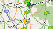
 We’ve had a busy start to the year, so we’re happy to announce the launch of Interactive Maps for CheckMyCCTV, now it’s even easier to keep a track of the status of all your sites.
By utilising the interactive map function, users can display site locations and corresponding status on a map using colour coded markers. It is easy to locate sites geographically, rather than just from the site tree – useful if you have many sites around the country (or world for that matter), or the operators are unfamiliar with the site locations.
The maps are fully interactive, so by clicking on a marker on the map, CheckMyCCTV software will display the status of that unit. It is also possible to display units grouped by site, customer, or alert type. The map will automatically update and resize so you will always see your sites in the optimum display format.
In line with our policy of offering the latest core features to existing users. Click on Help > Check for updates within CheckMyCCTV and and following the instructions to download Interactive Maps for FREE.
If you would like to see how CheckMyCCTV can help you manage multiple CCTV sites and locations, contact us and we’ll arrange a 14-day FREE trial.